A geological survey of the region Causses, Cévennes and Mont Lozère
The region of the Cevennes, Causses and 'Gorges' constitutes the Southern Central Massif ; It's a transition-zone in between the "garrigues" of the south Languedoc and the Central Plateau.
Topography and geology are closely related, both they define the the natural zones.
The steep declivities of the Cévennes consist of metamorphical bedrock dating from the primary era. It's a country with deep valleys separated by sharp crests, almost without flat parts.
Analogous terrain prolongs the Cévennes to the North-North-East direction by the Vivarais.
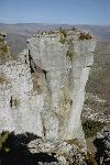
South-Westwards there is the giant tabular plateau of the Grands Causses, carved out by the famous Gorges, vertiginous and beautiful, like the Gorge du Tarn and those of de la Jonte.
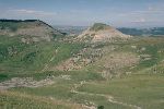
These big limestone tables are formed in the secondary era.
The Mont Lozère and the Mont Aigoual, two big granitic massifs which enclose the region respectively in the North and the South.
They also have been formed in the primary era; they are the frame of the region. The Margeride a bit further to the North their is comparable.
In the South and the East the typical garrigues of the Languedoc are the first echelon of the Cévennes.
The presence in the South of the coal basin of Alès also is a very remarkable geological caracteristic
.
THE GEOLOGICAL HISTORY OF THE CEVENNES
In the Precambrien, the middle of the primary era (between minus fivehundred and threehundred million years) there was only ocean all-over.
Enormous layers of clayey mud, marl, some limstone mire and different sorts of sand settle down at the bottom of the sea.
This proces took hundreds of million years; the actual layer still is several thousands meters. These sedimentary strata are eroded older mountains.
A lot of fossils attest to the vanished traces of life.
Long chains of granitic mountains rose throughout the crust of the earth surface without coming systematically to the surface.
These granitic magmas toil slowly through the layer of five à six kilometers depth towards the surface, across the other more heavy bedrocks.
This way the birth of the Mont Lozère and the Mont Aigoual transform the sedimentary rocks into metamorphical rock.
The very high temperatures of the magmatical rock and the enormous pression raise, distort, fold, crush, break, warm and even bake the bedrocks which mineral structure changes; they modifie and blister. They become gneiss and micaschist, the micaschist of the heart of the Cévennes and the cristallin limestone of the Viganais.
This mouvement takes decades of million years with alternate active and calm periods.
Some calm periods lasts such a long time that erosion has got time again to attack the new-builded summits to settle down the material in the most hollow zones like the coal basin near Ales
.
Now the structure is there:the granitic massifs Mont Lozère, la Margeride and the Mont Aigoual (called Saint Guiral longtime ago) and the lower zones: the Cévennes and the Causses.
This ensemble is rigid, the granite don't fold because it's out of one mass and the later working mouvements to it only cause modifications in detail like fissures and no folds (deformation).
At the end of the primary era everything calms down, erosion resume, wearing down the slatestone crests and stripping of the granitic rock, filling up the lower neighbour-parts like Lodève and Saint-Afrique.
Suddenly a new phenomenon occurs, the sea which we thought to be gone for ever starts recovering the left terrain, submerging the region little by little, now twohunderdfifty million years ago.
She deposit new sediments, at first the sands and sandstones which delimit the old shore, then the marnes with numerous blisters of mica which proves the erosion continues in the old granitic and slatestone massifs.
In the end a big layer of limestone is deposited, which orinigally certainly sticked out a lot compairing with the nowadays known limit, maybe even she covered the totality of the Cevennes.
This explains the rarely found formations of corals and shells which proves it once has been a deep underwater spot.
About hunderdtwenty million years ago a slight lift up occurs and the sea quits the region, still staying at the foot: les garrigues of the Languedoc and the Rhône-valley, leaving there also bit by bit.
Then a new mountain chain is coming up: the Pyrenees. This movement also lifts up the Alpes. A countermoving lift up our region and at the same time propulsives from the South crush the sedimentaryires secundary layers against the granitic chains. This creates a multitude of folds and fissure tectonic compression.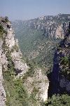
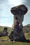
Les trucs de Bondon, limestone layer at hight
Fissures appear, as well as the first volcanoes in the North and the West.
From then on only the erosion determines the actual aspect, she fashions our region in the thousands of valleys and dales with sharp crests of the Cévennes and wears out the deepness of the Gorges which divides the big limestone plateau in the Causse Mejean, the divides the big limestone plateau in the Causse Mejean, the Causse noir, the Causse de Sauveterre and the Causse de Larzac.
 Campsites
 Hotel-Restaurants
 Hiker's accommodations
 Bed & Breakfast
 Selfcatering cottages
 Group gîtes
 Quirky accommodations
 Holiday villages